File:JarnfolkMap.jpg
Sarna News


No higher resolution available.
JarnfolkMap.jpg (459 × 420 pixels, file size: 87 KB, MIME type: image/jpeg)
JarnfolkMap.jpg
Information:
Summary
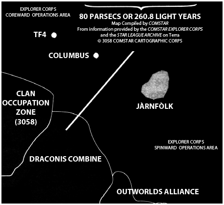
Periphery Map how shows the JàrnFòlk system
Artist
N/A
Source
Explorer Corps (sourcebook), p. 48
Licensing
 This work is copyrighted. The individual who uploaded this work and first used it in an article, and subsequent persons who place it into articles assert that this qualifies as fair use of the material under United States copyright law.
File history
Click on a date/time to view the file as it appeared at that time.
Date/Time Thumbnail Dimensions User Comment current 11:43, 20 August 2009 
459 × 420 (87 KB) S.gage (talk | contribs) Map adapted by S.gage from Explorer Corps (sourcebook), pg. 48. Fair Use.
You cannot overwrite this file.
File usage
The following page uses this file:
Metadata
JarnfolkMap.jpg
| Information: | |
|---|---|
| Summary | Periphery Map how shows the JàrnFòlk system |
| Artist | N/A |
| Source | Explorer Corps (sourcebook), p. 48 |
| Licensing |
|

Click on a date/time to view the file as it appeared at that time.
| Date/Time | Thumbnail | Dimensions | User | Comment | |
|---|---|---|---|---|---|
| current | 11:43, 20 August 2009 | | 459 × 420 (87 KB) | S.gage (talk | contribs) | Map adapted by S.gage from Explorer Corps (sourcebook), pg. 48. Fair Use. |
You cannot overwrite this file.
The following page uses this file: