In September, MechFactory released a new and improved iteration of their ISCP, or Inner Sphere Cartography Project. This was announced on their main page which includes an overview of its changes.
For more we asked MechFactory’s owner, Pheonix Wolf about the changes:
BobTheZombie: How and when did this project get started?
Phoenix Wolf: An early idea to create an interactive stellar map of all known BattleTech worlds appeared around 2001. That time we had only a deprecated 16 bit program and a text file with coordinates for 3025-era planets. I thought that a better, usable internet-based map would be a great tool for BattleTech players – especially for those people, who –like my team- are playing BattleTech RPG (MechWarrior was the name at that time). I took the data and began building the first mapping system on php/javascript basis.
Although in some aspects the first version was a failure (technology at that time was unable to handle such a big map in a browser, making it very slow), it proved the concept to be viable.
Shortly after the first map, I assembled a team of Mech Factory contributors to create a more sophisticated second version. We named it the Inner Sphere Cartography Project (ISCP), and started work. I created the second version’s Flash-based interface (with some expert help from Endrosz, who was also Commando that time), and during this time Shadowhawk and Killer took the map database, corrected it, mapped missing planets using 3063 official map files, and created affiliation information. Cartographers that time used Photoshop and Excel to pinpoint locations; it was tedious work.
Somewhere at the end of development we found a table named Encyclopedia Galactica that had descriptions (mostly from the 3025 era) about most of the Inner Sphere’s planets. We reviewed and cleaned it, and integrated that database with ours. Although ENCGAL is not a canon source, it is quite good.
The second version was a moderate success, lots of people loved it. It had a route planner, descriptions, search and almost all the features we have today. But it was Flash, and Flash means trouble. Trouble for us, programmers, trouble for the users. The team also disassembled after the creation and we looked for other tasks. The Mech Factory is big, and there are always missing designs.
In 2014 I reviewed all the site’s features: what can I transfer to the mobile platform and what will remain online-only. I stumbled into the nearly forgotten map database and after the Android app’s success I decided to port it into the app. And, because to that I had to entirely reorganize the database, I decided to create an appropriate online version too.
BobTheZombie: How many people are currently working on the ISCP?
Phoenix Wolf: The original ISCP team consisted of me (programmer, founder, nerving everybody with new ideas and schedules, etc. ), Endrosz (software architect, user interface, feature ideas, critics, route planning algorithm), Shadowhawk (cartographer, new planets, QA), GO Killer (cartographer, corrector of old maps, QA). The team dissolved after the second version.
The third, 2014 version was created exclusively by me, but it is based solely on their work.
BobTheZombie: This is the third edition; what were the other two like?
Phoenix Wolf: The first version was almost unusable, because it was slow. It could only display the map and search for a planet. Fancy functions were never realized because of this version’s limitations. We abandoned it and made the second.
The second version was a Flash based thing. It had online and offline edition. We still retain this version, because it is the only that can run offline. The second is fast, but cannot be resized to any display sizes. Remember what the typical display sizes were in 2003? It was almost full screen that time. Now it is a small window…
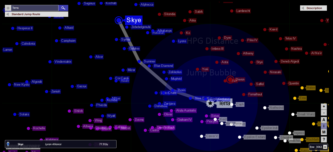
Screenshot of the current map, complete with jump range, HPG range, route planner, and more
BobTheZombie: What is new in this version?
Phoenix Wolf: First of all, there are two third versions – mobile and online.
The online has everything that the first two had, but it does not need anything other than an HTML5-capable web browser (that means no IE, but runs smooth in Chrome or Firefox). It functions very much like Google Maps: a search box in the left upper corner with suggestions, a route planning panel under it, and descriptions in the right. The map can be panned and zoomed as you like. Geographic information and affiliations can be obtained. Route planning works more sophisticated with a single click on a planet. A bitmap-based map of the corresponding era can be displayed under the database generated stars. Jump/HPG ranges and influence areas are shown as before. In the detail page of online version (nowadays we call it the planetary database) you can search by affiliation and planet name. The detail page has cross-referenced the information with our segmented design-database, and therefore can pinpoint what war machines are manufactured on a given planet (industrial capacity). We also search into our document database if there is a reference to a planet in any of them.
The Android mobile app version – pioneered in v2.6 – has almost the same functionality, except the route planner. Because of this exchange, it is quite fast. Mobile browsers struggle with the online version, because that consumes a lot of memory (sometimes 300M+). The app doesn’t have such a problem.
With the new version’s interface, I can correct the misplaced stars in our database. I counted about two dozen errors, but only a few were major. I have also found a lot of contradictions in our maps: official map creators sometimes pushed stars for one direction or another, and therefore maps from different eras does not overlap perfectly. There are also new stars (some understandably, like those in the New Colony Region, some not), and lot of corrections in the Periphery. Some stars might be completely missing – I’m almost sure, that the stars connected to the former Rim Worlds are not the whole set. I corrected affiliations for maps (2570-2750, notably with the Rim World territories, but some in the Kurita/Steiner border), and created the 3068 (Jihad time) map from one of the Jihad Sourcebooks.
BobTheZombie: What do you plan to do next with this project?
Phoenix Wolf: The ISCP always developed organically. I’ve already built my ideas into this version, but people may suggest new features. We are always open to that.
What we lack is the post Jihad era maps. Maps for 3081, 3132 and 3145 should be created. We have the tools (much better than we had in 2003), and are searching for a cartographer. After that… maybe route planning to the mobile app (still undecided), or the extension of the old ENCGAL information. Both of these would nice to have.
To check out the project and their work, see the below links:
The Original Interactive Star Map that the Net BattleTech League used was created by a member of House Kurita under my leadership buy a MechWarrior callsign Sutherland which is the young mans real last name. There was no massive project, the kid did the entire thing on his own and Pheonix used it in his leauge.
I just checked this out, I’m working on a legit novel at the moment. This is amazing! This is going to make it a lot easier to add depth to my storytelling.