File:ChainelaneIslesMap.jpg
Sarna News


Revision as of 00:23, 24 August 2009 by S.gage (talk | contribs) (Map adapted by S.gage from the map published on pg. 48, Explorer Corps (sourcebook). Fair Use.)
No higher resolution available.
ChainelaneIslesMap.jpg (465 × 404 pixels, file size: 95 KB, MIME type: image/jpeg)
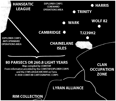
Map adapted by S.gage from the map published on pg. 48, Explorer Corps (sourcebook). Fair Use.
File history
Click on a date/time to view the file as it appeared at that time.
Date/Time Thumbnail Dimensions User Comment current 00:23, 24 August 2009 
465 × 404 (95 KB) S.gage (talk | contribs) Map adapted by S.gage from the map published on pg. 48, Explorer Corps (sourcebook). Fair Use.
You cannot overwrite this file.
File usage
The following page uses this file:
Metadata
Map adapted by S.gage from the map published on pg. 48, Explorer Corps (sourcebook). Fair Use.
Click on a date/time to view the file as it appeared at that time.
| Date/Time | Thumbnail | Dimensions | User | Comment | |
|---|---|---|---|---|---|
| current | 00:23, 24 August 2009 | | 465 × 404 (95 KB) | S.gage (talk | contribs) | Map adapted by S.gage from the map published on pg. 48, Explorer Corps (sourcebook). Fair Use. |
You cannot overwrite this file.
The following page uses this file: