BattleTechWiki talk:Project Systems
Sarna News


The Mapping Project is actively seeking input and involvement from Sarna's Editors and users.
In order to promote effective communication and project progress, please determine which of the following sections are most applicable and initiate conversations in that section. If you have an idea that is rather different in scope than what is being discussed, please consider opening another independent thread to that conversation.
Conversations will be periodically (and irregularly) archived.
Contents
Audit
- reference: BattleTechWiki:Project_Planets/Mapping#Audit
Corrective Services
Article Mapping
Input regarding the primary map
Gruese is seeking user input as to how the maps would best serve the system articles.
Using the Sarna system article as an example, system articles generally have a map in the right top corner, initially generated by Nicjansma when he first opened Sarna's BattleTechWiki. However, through a number of issues detailed elsewhere, these maps are often inaccurate relative to present canon. The Project: Planets team has done an incredible job in trying to ensure that accurate coordinates are presented within the article and updating this primary map image (when possible) with manually-modified images that are more accurate in the presentation of positions.
However, the Mapping Project is seeking to standardize these images across all system articles, in a way that is both accurate and easy to correct, update, and upload.
In his initial work, Gruese has created a series of test images. The below gallery allows you to compare the present image for Sarna to the test image:
- Sarna Neighbors.png
Auto-generated December 2007
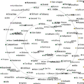
Mapping test image
.png)
One of the first things you'll notice is the difference in positions of planets: some have moved, others added. The test image is far more accurate, as it is based upon the Extrapolation Method of the SUCS. Both images depict about the same area of space, over 60 light-years out from Sarna, with 30- and 60-ly rings. The test image is far "busier" than the original, attributed to several reasons, including slightly differing scales and different fonts and font sizes.
Here's the request he making: what can he do to make the newer map images more useful to the Sarna user? Ideas he's already received from offline Mapping Project discussions include:
- retained 30- and 60-ly jump rings
- standardized 1000x1000 pixel size
- directional arrow to Terra (with distance)
- a minimap to help with positional reference (now a separate goal of the Mapping Project)
- shaded background to match the political affiliation; in other words, instead of a white background with colored dots, the idea is to have featureless dots on a background matching the color of the realm. In this case, that background would have green for the Capellan Confederation under all of the systems shown that are controlled by them, and yellow and purple for the systems per their relevant realms (see "Example image" here, from the IS 3025 site).
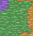
Example image
.png)
For discussion purposes, what else would make this map useful (but hopefully not too cluttered)? --Revanche (talk|contribs) 14:47, 20 June 2018 (EDT)