Difference between revisions of "File:PeripheryLayout2.jpg"
Sarna News


m (Adding Imagebox) |
Csdavis715 (talk | contribs) m |
||
| (One intermediate revision by one other user not shown) | |||
| Line 1: | Line 1: | ||
| − | |||
{{Image summary | {{Image summary | ||
| − | | summary = | + | | summary = Major Geographic Zones of the [[Periphery]], ca. [[3025]] |
| artist = | | artist = | ||
| − | | source = [[The Periphery (sourcebook)]] | + | | source = ''[[The Periphery (sourcebook)|The Periphery]]'' (1988), p. 156 (appendix) |
| licensing = {{fair use}} | | licensing = {{fair use}} | ||
}} | }} | ||
| + | |||
[[Category:Maps Gallery]] | [[Category:Maps Gallery]] | ||
Latest revision as of 02:32, 29 September 2023
PeripheryLayout2.jpg
| Information: | |
|---|---|
| Summary | Major Geographic Zones of the Periphery, ca. 3025 |
| Artist | Missing artist |
| Source | The Periphery (1988), p. 156 (appendix) |
| Licensing |
|

File history
Click on a date/time to view the file as it appeared at that time.
| Date/Time | Thumbnail | Dimensions | User | Comment | |
|---|---|---|---|---|---|
| current | 15:37, 11 May 2010 |  | 500 × 450 (40 KB) | Mbear (talk | contribs) | {{Image summary | summary = Image taken from The Periphery (sourcebook), p. 156 (appendix), formatted and sized by S.gage. Updated version by MBear reformatted to use GIF encoding instead of JPG to reduce file size significantly. | artist = The image is n |
| 11:14, 5 August 2009 | 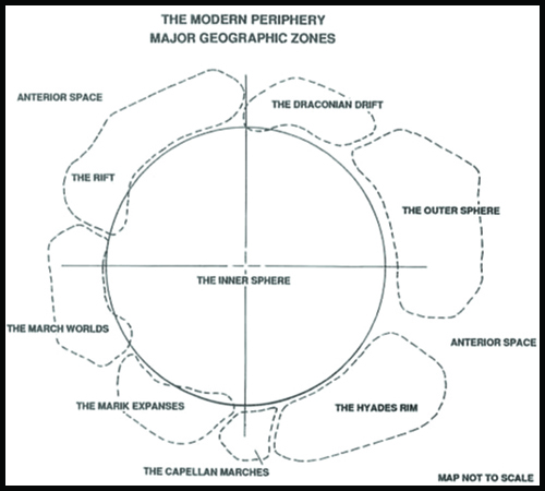 | 500 × 450 (688 KB) | S.gage (talk | contribs) | borders even now | |
| 11:08, 5 August 2009 | 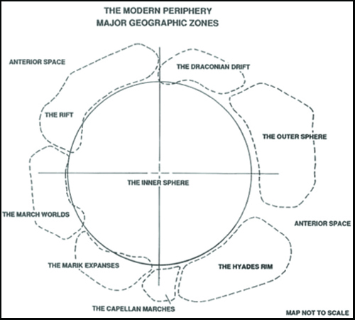 | 500 × 450 (688 KB) | S.gage (talk | contribs) |
You cannot overwrite this file.
File usage
The following 2 pages use this file: