Difference between revisions of "File:CalibanNebula.png"
Sarna News


m (image info) |
m |
||
| Line 1: | Line 1: | ||
{{Image summary | {{Image summary | ||
| − | | summary = A low-resolution map of the known [[Coreward|coreward]] [[Deep Periphery]] as of [[2821]]. | + | | summary = A low-resolution map of the known [[Coreward|coreward]] [[Deep Periphery]] as of [[2821]]. The small-hatched line represents the path of the [[Exodus Fleet]], the star represents the approximate location of the [[Prinz Eugen Mutiny]], and the large-hatched line represents the Periphery boarder of the defunct [[Rim Worlds Republic]]. Clusters of known populated systems and nebulae are labeled. |
| artist = The image is not directly attributed to one artist (see ''Historical: Operation Klondike''. Both [[Øystein Tvedten]] and [[Ray Arrastia]] are listed in the credits; the map is most likely the work of Mr. Tvedten) | | artist = The image is not directly attributed to one artist (see ''Historical: Operation Klondike''. Both [[Øystein Tvedten]] and [[Ray Arrastia]] are listed in the credits; the map is most likely the work of Mr. Tvedten) | ||
| source = This image is adapted from ''[[Historical: Operation Klondike]]'', p. 135, formatted, sized, and inset removed by [[User:S.gage|S.gage]]. | | source = This image is adapted from ''[[Historical: Operation Klondike]]'', p. 135, formatted, sized, and inset removed by [[User:S.gage|S.gage]]. | ||
| licensing = This image is owned by its copyright holders. "Fair Use" | | licensing = This image is owned by its copyright holders. "Fair Use" | ||
}} | }} | ||
Revision as of 00:33, 8 March 2012
CalibanNebula.png
| Information: | |
|---|---|
| Summary | A low-resolution map of the known coreward Deep Periphery as of 2821. The small-hatched line represents the path of the Exodus Fleet, the star represents the approximate location of the Prinz Eugen Mutiny, and the large-hatched line represents the Periphery boarder of the defunct Rim Worlds Republic. Clusters of known populated systems and nebulae are labeled. |
| Artist | The image is not directly attributed to one artist (see Historical: Operation Klondike. Both Øystein Tvedten and Ray Arrastia are listed in the credits; the map is most likely the work of Mr. Tvedten) |
| Source | This image is adapted from Historical: Operation Klondike, p. 135, formatted, sized, and inset removed by S.gage. |
| Licensing | This image is owned by its copyright holders. "Fair Use" |
File history
Click on a date/time to view the file as it appeared at that time.
| Date/Time | Thumbnail | Dimensions | User | Comment | |
|---|---|---|---|---|---|
| current | 00:13, 8 March 2012 | 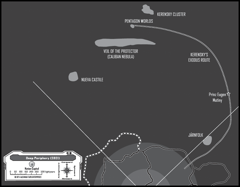 | 833 × 649 (249 KB) | S.gage (talk | contribs) | {{Image summary | summary = | artist = | source = | licensing = }} |
You cannot overwrite this file.
File usage
The following page uses this file: