Difference between revisions of "File:CalibanNebula.png"
Sarna News


m (typo) |
Dirk Bastion (talk | contribs) m (categorising) |
||
| Line 5: | Line 5: | ||
| licensing = {{fair use}} | | licensing = {{fair use}} | ||
}} | }} | ||
| + | [[Category:Maps Gallery]] | ||
Revision as of 09:22, 1 May 2013
CalibanNebula.png
| Information: | |
|---|---|
| Summary | A low-resolution map of the known coreward Deep Periphery as of 2821. The small-hatched line represents the path of the Exodus Fleet, the star represents the approximate location of the Prinz Eugen Mutiny, black lines are the borders of the Great Houses, white lines demarcate the borders between sectors of space (clockwise: Anti-spinward, Coreward, Spinward), and the large-hatched line represents the Periphery boarder of the defunct Rim Worlds Republic. Clusters of known populated systems and nebulae are labeled. |
| Artist | The image is not directly attributed to one artist (see Historical: Operation Klondike. Both Øystein Tvedten and Ray Arrastia are listed in the credits; the map is most likely the work of Mr. Tvedten) |
| Source | This image is adapted from Historical: Operation Klondike, p. 133, formatted, sized, and inset removed by S.gage. |
| Licensing |
|

File history
Click on a date/time to view the file as it appeared at that time.
| Date/Time | Thumbnail | Dimensions | User | Comment | |
|---|---|---|---|---|---|
| current | 00:13, 8 March 2012 | 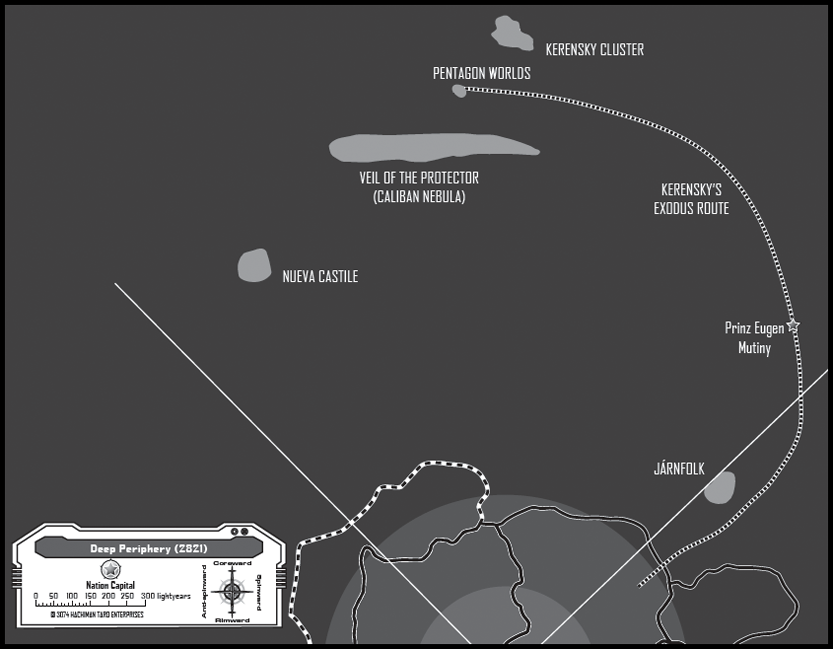 | 833 × 649 (249 KB) | S.gage (talk | contribs) | {{Image summary | summary = | artist = | source = | licensing = }} |
You cannot overwrite this file.
File usage
The following page uses this file: