BattleTechWiki talk:Planet Article Overhaul/Archive
Sarna News


Holla
Hy i have the planet cartographer, thanks for the provided link in the past, but how can i use it, must i have a planet data base, i want to bring in the next next next future new plant images, seriously updated by canon sources, must i create my own database, and how i become correct x and y coordinates, must i interpolate maps, how can i handle this problem.--Doneve 23:56, 31 July 2011 (UTC)
- I've since added a link to the database for determining coordinates, but I suggest you go to [1] and search for 'cartographer'. Download that program and the database is included. However, I'd hold off on creating new images. I think I may know of a way to have Nix do it automatically, using updated coordinates.--Revanche (talk|contribs) 01:35, 1 August 2011 (UTC)
- Hm, i know you provided in the past a cartographer link, but it is not the provided link in the top, can you give me a workable link, thanks.--Doneve 01:50, 1 August 2011 (UTC)
Cartography
From what I remember reading on the CBT forum, I think those working on the jump-mapping software are affiliated with those producing the MechHQ software that's used for people playing campaign games and running the Against the Bot campaign? That's where I heard about it - it was being cited as being of use when generating merc contracts and trying to work out transport costs/compensation.
You raise a lot of good points in your essay - I hope you don't mind me responding at some length? I've an interest in this because I really love maps, and one of the things that attracted me to BattleTech in the first place were the great maps in the second volume of the NAIS Atlas of the Fourth Succession War.
1. Co-ordinates: These are sort of useful, but not hugely useful, in their current form. While it can be handy to be able to work out how far apart two systems are, it's not really much use for calculating transit times because you need to work out which system en-route you're going to be jumping through. By far the biggest problem with the current entries is that as CGL have stated that they want to produce maps for each era to allow games to be played in those eras, there are lots of new Star League/Age of War era planets being added for which there are no official co-ordinates.
2. Nearest neighbours: I like the idea behind this auto-generated imagery, but it doesn't work particularly well at the moment; not only is it broken for areas like the Rim Collection, but there's no way of easily adding in new planets without knowing the co-ordinates and then manually re-working the tables. Given the number of planets, number of maps and number of co-ordinates involved, that has to either be automated or it becomes a huge man-hours sink with limited utility.
3. Categories: I love categories. I think as wiki functionality increases, categories will see more use from automated scripts, but even at the most basic level I think categories are amazingly useful. I really like knowing which factions a planet has been a part of, and I like knowing how large factions have been in terms of star systems at one time or another. The more categories the better, as far as I'm concerned!
4. Owner History: I find this section to be useful but flawed at the moment. For the majority of planets, it reflects the major eras used for game play, as set up by the original atlas team. That has it's uses, but it lacks citations in most cases, and as you've already said, it only gives a series of benchmark dates. CGL are shifting to making sure that there are maps for certain years for all realms, to use as jumping-off points for games, and having the wiki reflect that is handy; where I'd hope the wiki can go further is through showing when planets changed hands, with citations/references. That might make for the a very long owner history section, but it is the sort of thing that as a BattleTech player, I'd be coming to the wiki to look up - dates planets changed hands, the name of the campaign if appropriate, the factions involved.
5. Deployment Data: only a small percentage of planets have actual garrison forces described and listed in canon, because of the focus on Mech forces, but where it's known, I think it should be listed on the planet entries. The feeling I have is that a lot of planets have no garrisons of note, and that the greater part of those for whom a garrison has been listed, that garrison is a single unit, with the remainder having multiple units at the same time. That could lead to a lot of clutter, but at the same time if I'm using the wiki for research before a game or campagin, it's the sort of detail I want to know. There are a lot of eras without those spiffy deployment tables that are in things like Field Manual: Periphery, and there are a lot of places where past unit deployments are mentioned scattered throughout House books, mercenary supplementals and the like. The wiki is where I'd hope to find that information tied together, and the planets are the lowest common denominator for being able to actually research that.
6. Minimaps: This is something I'd like, although it may involve a lot of work to set up. Basically, showing me what a planet's immediate neighbours are in the current format doesn't do me a lot of good unless I know what those neighbours are. A lot of worlds are relative backwaters not particularly close to planets of note. Saying a planet is within the Isle of Skye or the Stewart Commonality is more useful. What would be better is linking to actual maps, so that I can go find the planet in question and work out the local astrological astronomical geography for myself. At the moment though, none of the planet entries seem to link to actual maps, be they the big system maps or the smaller maps showing troop and border movements. I know that I can go out and find those maps with some effort, but why not link directly to them in the planet articles?
BrokenMnemonic 12:06, 1 August 2011 (UTC)
- No problems at all in your responding to this. It is not yet complete, which is why I have it on my user space. When it's done, I'll move it to the BTW space. I /do/ (and will) seek comment, as a lack of involvement at the essay level will tell me that any attempt to overhaul the articles will fail due to overwhelming workload amounts.
- Jump-mapping software: I was unaware of this conversation (or have forgotten it), but by using the incomplete program so far, I did see where Bad_Syntax has built in the option to include variables for the purpose of determing contract values. I'm attempting now to get a hold of him to make sure I understand correctly his method for determining the coordinate values he provided with the program's database.
- Coordinates: you have started me thinking about the value of those coordinates. What purpose do they serve on Sarna? I was thinking I want them to be as precise as possible, but to what end? Even if I knew they (each & every one) were perfectly representative of a system's location...I would never come to Sarna just to see the coordinates. I'd come to see a map or read the textual description of their location. For an in-character purpose, the coordinates are critical; they tell the in-character reader where the system is. But for the real world reader? Is he going to come here to jot down the coordinates? Or will he come to see the map associated with it? Would you advocate for tossing the coordinates (maybe creating an article that lists them instead) or keeping them on each article?
- Nearest neighbours: So, let's do away with that section and...get this...import cropped images of canon maps for the map imagery. At most, each image will need a jump scale added to a corner of the map (since it would be cropped off by the centering on the subject system). Or, we can import the faction (or region) map in its entirety and color the subject system to highlight its location.
- I had been toying with the idea of fixing all of the coordinates by official location and/or interpolation and providing them to Nic, to regenerate the current images, but I'm coming to appreciate the idea of having regional (canon) maps for the infobox graphic instead.
- Categories: I'm somewhere in between the 'fetish' (
 ) you have for categories and Frabby's concern of overpopulating an article with them. In my work this last week on populating the planetary articles I was concerned by some that just seemed to blow-up with two or more lines of categories at the bottom, but I'm leaning towards the realization that those bottom-located categories don't really affect the article itself, but do provide rather awesome 'lists' when categories are properly organized in a hierarchy.
 - Owner History: I don't think we'll find many people (if any) that will disagree with the re-working of this section. I admire the informative nature of the ones you've improved, with the citations showing once again how important they are establishing their veracity.
- Deployments: There is value in this information; I have no doubt. It could be argued that the deployment data is best left in the unit articles, but as you've said, if you're targeting a specific world for a mission, it's a lot easier to do it via the planet article. You could search the wiki for that planet name, but the unit deployments could get lost amongst the other search returns.
- Mini-maps: I presume you meant 'astronomical'.() Freudian slip, I'm sure. However, in regards to mini-maps, I think the infobox graphic would be the best place for a representative image of the subject planet's neighborhood. Any galleries in the planet article should be limited to maps specfically about the subject planet (ex: their use in the Imperial City article). Multiple maps depicting the evolving nature of that neighborhood would, in my opinion, be best served on the faction's article. However, links to those maps, especially within the History section, would be appropriate.
- I'm thinking you and I should grab a planet article and do a demo overhaul. Are you up for it?--Revanche (talk|contribs) 14:23, 1 August 2011 (UTC)
- Coordinates:' As it stands, I don't think the co-ordinates add any real value at this point in time. We aren't sure of their parentage or veracity, they're incomplete, and unless someone wants to answer a very, very specific question like "How far is it from New Avalon to Sian?" they aren't going ot be used. Where they might be useful in the future is if the wiki becomes capable of generating responses based on user queries of some kind - but why would we want the wiki to replicate the co-ordinate mapping software? I'm really twitchy about the fact that technically, the co-ordinates are basically fanon as it stands. They may be potentially really accurate fanon, but I'm not sure that they have a place here.
- Nearest neighbours: I really, really like this idea; I'd recommend colouring parts of the map if we can, to bring it further into the fair use domain, but I think it's a splendid way of highlighting where a world is. Realm maps are probably the easiest way of doing this for a fair number of worlds, but even if we end up linking to certain era maps I think it's great to have a mini-map showing where the planet is in relation to a couple of significant points, like a House capital or a time-specific border or something equally attention-grabbing.
- Categories: I think the categories are great where planets are concerned, as you've probably noticed! I think most planets aren't likely to get many - perhaps 2-3, if we include the proto-state maps from the House founding maps. There are going to be planets where there are a lot, like former Terran Hegemony worlds that have bounced between three different houses, the Republic of the Sphere, plus a relocated clan, Chaos March world and the likes... but categories give us a way of looking at specific lists of information. I love the idea of being able to check how many worlds were in the Tamar Pact, or the United Hindu Collective. Or things like the Traders Domain in the Outworlds Alliance, in theory. Where there are a lot of categories, it highlights how states and nations have evolved in the in-game universe, or just how much conflict some worlds have been through.
- Owner History: Thank you. I'm a bit of a citations nut, and I know that with planets we're in danger of having potentially a dozen citations for each date in some cases, but adding citations is a good habit to be in generally I think. I have found that a fair number of the existing world categorisations are a bit dubious - particularly those from the Star League era, where I found a lot of discrepancies along the Capellan March/Capellan Confederation border, and the DC/FS border near the Outworlds Alliance. Some of that could be retconning, but it makes me wonder if perhaps the 2750 dates generated by the Inner Sphere atlas are based on old information or speculation.
- I'm up for helping with a prototype article In fact, it might be worth doing a couple, to show the left and right of arc as examples - an article for somewhere fairly quiet, and an article for a planet that's been through a lot, changed hands, usually has someone deployed there. Where would you like to start?
- I'm up for helping with a prototype article
- I wish I knew where astrological crept in from... that's going to worry me! BrokenMnemonic 17:36, 1 August 2011 (UTC)
- Good idea. For the expanded one, we want something that will have enough meaty information to demonstrate the potential, but not one that is so big it 'fails' but what we are unable to bring to it for the purpose of demoing it (thinking Terra, Luthien, etc, as examples of too big for this example). What about Wolcott? Turtle Bay? Alpheratz? ...Sarna? What do you suggest? As for the smaller, I'll let you pick that.--Revanche (talk|contribs) 03:41, 2 August 2011 (UTC)
- I had a think on the way in to work this morning as to what worlds might make for a good but not daunting example for an initial run. I'm a little reluctant to suggest a world that is/has been a Draconis Combine world because Handbook: House Kurita isn't out yet, so we don't have the founding era maps and Age of War maps for a lot of the Combine unless they're caught within the overlap with the other House handbooks. Sarna could be good, as that planet's been garrisoned on a regular basis and has moved through several states as well as being a big part of the 4th SW. I thought Van Diemen IV might also be a good candidate; it's moved through various hands from the Terran Hegemony to the Word of Blake, it gets a little detail in the early House books and was involved in the 4th SW and Guerrero. Caph could be good as well, although I don't know how much attention the world got before the Chaos March appeared.
- For the smaller piece, I'm thinking Rollis could be good; I need to check the field manuals and early house books to see if it's had troops deployed there, but it's changed hands a few times (Taurian Concordat to Federated Suns to Capellan Confederation by 2822) and a cropped map would show at least 3 different states on it, which could be visually effective despite the world not actually being that significant.
- Glad you re-found this conversation. I meant to PM you, to let you know it had moved.
- Ok, so I vote for Sarna, and I'll let you choose the smaller one. I'm thinking, when we're done with those two, we might also want a 'nobody' one, to show what the template will look like for a large number of the articles. We can cross that bridge when we get to it.--Revanche (talk|contribs) 11:39, 2 August 2011 (UTC)
- A 'nobody' example is a good idea too - I'm currently adding even more citations to the worlds in the Taurian Concordat, so perhaps one of them would be a good candidate?
- I've also discovered that with a bit of effort, I can produce not just mini-maps, but brightly coloured mini-maps. Would you like some for the Sarna article? If so, from which era(s)? BrokenMnemonic 13:06, 2 August 2011 (UTC)
- Hy, can you show us a example mini-map.--Doneve 13:19, 2 August 2011 (UTC)
- Yeah, I'm with Doneve. Can you provide an example?
- I was considering designating you as the Project Cartographer, but any method you did come up with would -by necessity- need to be done by most anyone else, as I don't forsee you doing all 2,333+ maps by yourself!--Revanche (talk|contribs) 13:24, 2 August 2011 (UTC)
- I can, if you can explain to me how to upload an image to the wiki. Having played around with images from the southern end of the Capellan Confederation, what I'd suggest is that a lot of planets share mini-maps - a lot of the maps would show very similar areas to begin with, and by the time you've expanded the map boundaries to include a reasonably-well known reference point, they'll include a lot more by way of worlds. As an example, the mini-map I was looking at possibly using for Girondas would also be perfectly useable for Qalzi, Katinka, Brinton, Enkra, umgard, Smithon, Tyrion, Itrom... the hard part is picking the era(s) to map from, because a lot of planets vanish after the Star League era.
- I may need to send the image files home to be able to upload them, though. BrokenMnemonic 14:18, 2 August 2011 (UTC)
- I'm absolutely fine with one mini-map (good catchall term) that provides locations of multiple subject planets, as long as it provides a good overall visual representation of the subject planets' location, without drowning it in too many other planets. For example, we wouldn't want to show the whole of the Draconis March, just to provide an image for one planet. Also, that means we can't highlight the individual planet with color or other icon, if we go this route.
- Uploading should be easy, from where ever you have the images available. On the sidebar (to the left), near the bottom, you'll see a link named 'Upload file'. Within that, you browse to the image to be uploaded, and then fill in the summary template.
- The artist is not critical (for most of your uploads, though, [[Øystein Tvedten]] will suffice) nor is the summary field, but the source is important and the licensing is critical (I suggest using {{Fair use}}). In fact, I'd suggest creating a template, maybe in a text file, that you can copy and paste into the edit field, so that you don't have to type the source, artist and licensing info every time. Just hit upload, and we're good to go.
- I'll contact you on your talk page shortly regarding a research 'cache' of maps for which I have an idea.--Revanche (talk|contribs) 14:46, 2 August 2011 (UTC)
- OK, this is a low-res copy of one of the files I've made, although I'm not quite sure how to embed it into a talk page...
- File:New_Vandenburg_2864.png
- That's the area of the Taurian Concordat captured on the map for the end of the 2nd Succession War in Handbook: House Liao. And here's the same area as at 3025:
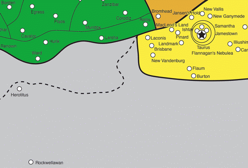
- I've deliberately dropped the resolution, as these are for demonstration purposes. Will these be good enough for mini-maps? Depending on the era used, we could end up with a lot of these... BrokenMnemonic 17:06, 2 August 2011 (UTC)
- I've embedded your first image, for your knowledge; just add a colon right after the opening brackets (it's also how you keep a category link visible).
- Here's the issue I have, BM: let's say the subject planet was Rollis. Since the image is not centered on the planet and nor is the planet colorized, it doesn't immediately leap out.
- But, you know what? We're at the 90% solution. We could really drag this project down if we get that specific. After the project concludes, an individual is free to upload an image with the system centered or targeted on the subject planet. Let's go with what you've demo-ed here.
- Two things we should talk about:
- -Image dimensions: not actually taking about size, but ratio. Do we want to make sure they're squared? Or does that matter, since the reader has to click on the image anyway to see the actual planets?
- -Maximum number of represented planets: because we're not centering nor targeting, we don't want too many planets in the image, to allow the reader to find the subject planet. Your first image has 56 planet dots in it. How long did it take you to find Rollis in the first image? How about Cavalor? What is your suggestion on our guidance as max number of represented planets?--Revanche (talk|contribs) 17:36, 2 August 2011 (UTC)
- - Planets: Finding a planet can be tricky, but it does mean walking a line between the number of maps generated and making the general location easily identified. In the case above, the colours help, but the thing that orientates me on the map is knowing that I'm looking at somewhere near Taurus and several major state borders.
- - Regions: In this case, I was experimenting with trying to show how the Concordat changed between the two eras, so my image size was based on the region I was trying to cover. I've found as I grab images that when you take the area covered down below a certain size, it becomes much harder on uncoloured maps to work out where you are - and when dealing with big states like the League, there are a lot of worlds that could be just about anywhere.
- - The first map is pretty much maximum population density in terms of planets; a handful of systems have gone, but generally speaking, the Star League/1st SW era maps will have more planets than any other. The second map has 30 planets on it, but covers the same region. In this case, I thought it was worthwhile to keep the areas covered roughly the same, to make tracking planets from one era to the next easier. In terms of time, I found Rollis immediately - but then I know where that planet is because of my recent reading. Cavalor took about six seconds, but I'm conscious that I've had some training at speed reading. I don't think I'd want to go much about 60 planets in an image, but even at that resolution, we're looking at a lot of maps for each era.
- - Dimensions: This one's tricky. I find rectangular images easier to read visually than square ones, but I don't know if everyone finds reading maps and images the same process I do. I'm not really bothered about maps being squared. I'm happy to go with the majority vote... BrokenMnemonic 17:57, 2 August 2011 (UTC)
- Okay, I replaced two two-jump image on the Taurus infobox with the 2864 image you provided. What do you think? What was your impression of the infobox when you first saw it and then -in character as a reader- what did you think when you saw the result of clicking on the image itself?--Revanche (talk|contribs) 18:41, 2 August 2011 (UTC)
- I like the look of it and the box - it's eye-catching. I think it's not right for the Taurus article, though - Tauris is a capital, so the image should probably be centred on it. It also makes me wonder which era we should go with, though - do we want Taurus at the height of it's power, or as close to the modern era as possible? I think the text is a little fuzzy, too. That's an artifact from the compression process, though; getting it down to 500 pixels whiles reduces the quality of the text, which is a pain. All in all, I think we're on the right track. BrokenMnemonic 20:25, 2 August 2011 (UTC)
- Good idea. For the expanded one, we want something that will have enough meaty information to demonstrate the potential, but not one that is so big it 'fails' but what we are unable to bring to it for the purpose of demoing it (thinking Terra, Luthien, etc, as examples of too big for this example). What about Wolcott? Turtle Bay? Alpheratz? ...Sarna? What do you suggest? As for the smaller, I'll let you pick that.--Revanche (talk|contribs) 03:41, 2 August 2011 (UTC)
- I wish I knew where astrological crept in from... that's going to worry me! BrokenMnemonic 17:36, 1 August 2011 (UTC)
